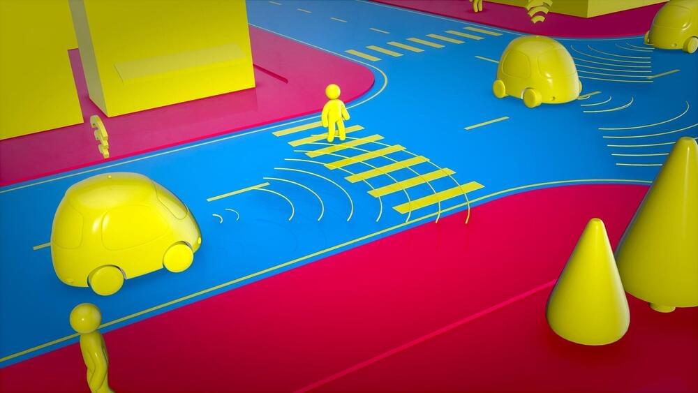
Robots and autonomous cars will have eyes that see much more than the human eye is capable of, a review of the growing field of meta-optics has found.
Meta-optics is advancing science and technology far beyond the 3,000-year-old optical paradigm that we rely on for the visual human-machine interface, such as through cameras in our mobile phones, the lenses in microscopes, drones, and telescopes. Optical components are the technology bottleneck that meta-optics aims to transform, bringing the stuff of science-fiction stories into everyday devices.
The field, which blossomed after the early 2000s thanks to the conceptualization of a material with negative refractive index that could form a perfect lens, has grown rapidly in the last five years and now sees around 3,000 publications a year.
The transportation system in the future will be very different from our current system. We will see flying cars, self-driving cars, passenger drones, hyperloop one system that is projected to reach a top speed of 760 mph (1,220 km/h) and with Starship and the Super Heavy Rocket, most journeys will taking less than 30 minutes, with access to anywhere in the world in an hour or less.
Starship-Super Heavy Earth to Earth : With Starship and the Super Heavy Rocket, most of what people consider to be long distance trips would be completed in less than half an hour. In addition to vastly increased speed, one great benefit about traveling in space, outside of Earth’s atmosphere, is the lack of friction as well as turbulence and weather. Consider how much time we currently spend traveling from one place to another. Now imagine most journeys taking less than 30 minutes, with access to anywhere in the world in an hour or less. It’s designed to service all Earth orbit needs as well as the Moon and Mars. This two-stage vehicle—composed of the Super Heavy Rocket (booster) and Starship (ship).
Hyperloop One : The Hyperloop is a new mode of transportation that moves freight and people quickly, safely, on-demand and direct from origin to destination. Passengers or cargo are loaded into the hyperloop vehicle and accelerate gradually via electric propulsion through a low-pressure tube. The vehicle floats above the track using magnetic levitation and glides at airline speeds for long distances due to ultra-low aerodynamic drag. Hyperloop One systems will be built on columns or tunneled below ground to avoid dangerous grade crossings and wildlife. It’s fully autonomous and enclosed, eliminating pilot error and weather hazards.
Underground Tunnels Transportation : To solve the problem of soul-destroying traffic, roads must go 3D, which means either flying cars or tunnels. Unlike flying cars, tunnels are weatherproof, out of sight and won’t fall on your head. A large network of tunnels many levels deep would fix congestion in any city, no matter how large it grew (just keep adding levels). Fast to dig, low cost tunnels would also make Hyperloop adoption viable and enable rapid transit across densely populated regions, enabling travel from New York to Washington DC in less than 30 minutes.
Pop. Up Next : At the heart of the Pop. Up Next concept is a simple two-seat passenger cabin that can travel one of two ways. The simpler and more conventional route involves attaching to a 60-kW (80-hp) electric powered sled and assuming the role of a self-driving car. Top speed is listed at 100 km/h (62 mph) and it would rely on a 15-kWh battery for a 130-km (81-mi) range. Pop. Up’s modus operandi is simple: passengers plan their journey and book their trip via an easy-to-use app. The system automatically suggests the best transport solution — according to user knowledge, timing, traffic congestion, costs, ridesharing demands — joining either the air or ground module or other means of transportation to the passenger capsule, and following passengers’ preferences and needs.
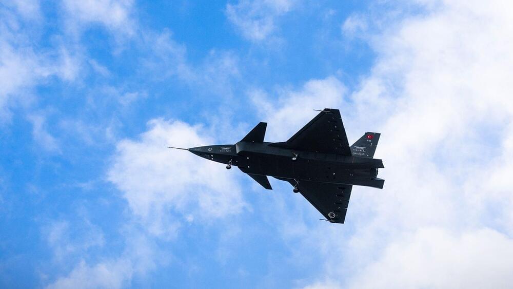
The drone is highly maneuverable, with a flight time of five hours and an operational altitude of 35,000 feet, as per the defense company.
Turkey’s first jet-powered uncrewed aerial combat vehicle (UCAV), Kizilelma, “Red Apple,” has completed its inaugural flight, as per the country’s lead defense manufacturer.
The makers of this new combat ariel vehicle, Baykar (a Turkish defense company), posted the test results via social media on Wednesday.
These Remote Carriers will supplement manned aircraft and support pilots in their tasks and missions.
A group led by Airbus has successfully tested the launch and operation of a Remote Carrier flight test demonstrator, a modified Airbus Do-DT25 drone, from a flying A400M.
The project, jointly developed with Germany’s Bundeswehr, the German Aerospace Center DLR, and German companies SFL and Geradts, aims to supplement the upcoming European sixth-generation fighter jet, part of the Future Combat Air System (FCAS). “Multiplying the force and extending the range of unmanned systems will be one of the future roles of Airbus’ military transport aircraft in the FCAS,” said in a release.
“Eureka 1” is an innovative underwater drone that can collect rare minerals from the seafloor without causing too much damage to the ecosystem.
Impossible Metals has announced in a press release that “Eureka 1,” its first autonomous underwater vehicle (AUV), has finished its first field test by carefully choosing pebbles to collect in an aquatic environment. This is a big step for the company, which wants to move toward a green economy by finding better ways to mine essential minerals.
This will be important because the demand for these metals will keep going up for the next few decades.
Impossible Metals.
All of this puts a massive strain on mining activities and will lead to a rise in demand for traditional and new ways to get raw materials.
For millennia, humans have been harnessing #microbes to produce everything from breads, to cheeses, to alcohol. Now these tiny organisms have produced another powerful revolution — the gene editing tool CRISPR. Rodolphe Barrangou, Ph.D., was working at the food company Danisco, where he was trying to produce yogurt lines resistant to contamination. In a series of groundbreaking experiments, he helped uncover what CRISPR was, how it worked, and why it could be so transformative.
Speaker Biography: Rodolphe Barrangou, Ph.D., studies beneficial microbes, focusing on the occurrence and diversity of lactic acid bacteria in fermented foods and as probiotics. Using functional genomics, he has focused on uncovering the genetic basis for health-promoting traits, including the ability to uptake and catabolize non-digestible carbohydrates. He spent 9 years at Danisco-DuPont, characterizing probiotics and starter cultures, and established the functional role of CRISPR-Cas as adaptive immune systems in bacteria. At NC State, he continues to study the molecular basis for their mechanism of action, as well as developing and applying CRISPR-based technologies for genotyping, building immunity and genome editing.
Producers: Sarah Goodwin, Rebecca Ellsworth. Cinematographer: Derek Reich. Editor: Rebecca Ellsworth\ Graphics: Chris George, Maggie Hubbard. Assistant Camera: Gray McClamrock. Drone aerials: Travis Jack. Supervising Editor: Regina Sobel. Field Producer: Meredith DeSalazar. Interview by: Adam Bolt. Associate Producer: Shelley Elizabeth Carter. Executive Producers: Shannon Behrman, Sarah Goodwin, Elliot Kirschner.
The experiments were done to prove the effectiveness of 70mm rockets.
BAE Systems has tested its latest drone hunting missiles machine by conducting ground-to-air test firings, according to a press release by the company published on Tuesday.
Rockets fired from a containerized weapon system.
BAE Systems.
The experiments were done to prove the effectiveness of 70mm rockets guided by APKWS guidance kits against Class-2 unmanned aerial systems (UAS) that weigh roughly 25–50 pounds and can travel at speeds exceeding 100 miles per hour.
As Amazon prepares to debut its long-delayed Prime Air drone delivery service, it’s also showing off a smaller, quieter drone that will be ready in 2024 and could be making regular deliveries in major cities by the end of the decade.
Why it matters: Consumers want their stuff fast, and under Amazon founder Jeff Bezos’ vision, they could get it delivered in as little as 30 minutes while helping the environment by taking CO2-emitting trucks off the street.
Technology — An investigation into the advancements in digital technology unique to the gaming industry. They can either enhance our lives and make the world a better place to live, or we may find ourselves in a dystopian future where we are ruled and controlled by the very technologies we rely on.
End Game — Technology (2021) Director: J. Michael Long. Writers: O.H. Krill. Stars: Paul Jamison, Razor Keeves. Genre: Documentary. Country: United States. Language: English. Release Date: 2021 (USA)
Synopsis: The technology we rely on for everyday communication, entertainment and medicine could one day be used against us. With facial recognition, drone surveillance, human chipping, and nano viruses, the possibility is no longer just science-fiction. Could artificial intelligence become the dominant life form?
Reviews: “Shocking insight into the possibilities that lie ahead.” — Philip Gardiner, best selling author.
“Well researched and highly captivating.” — Phenomenon Magazine.
Originally published on Towards AI the World’s Leading AI and Technology News and Media Company. If you are building an AI-related product or service, we invite you to consider becoming an AI sponsor. At Towards AI, we help scale AI and technology startups. Let us help you unleash your technology to the masses.
The model is able to transfer knowledge between a simulated environment and real-world settings.

